Observing - Basics of Astronomy 1
Star Charts and Setting Circles
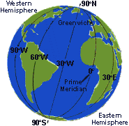
A star chart is like a road map; it indicates location and manners of measurement.
|
Observing - Basics of Astronomy 1 Star Charts and Setting Circles A star chart is like a road map; it indicates location and manners of measurement. |
|
|
|
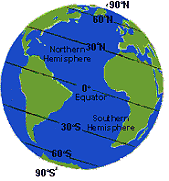
Memphis Tennessee is at 35 degrees North Latitude - closer (11.5 degrees) to the Tropic of Cancer (23.5 degrees North) than to the Artic Circle (at 68.5 degrees North) 33.5 degrees north of Memphis. Milwaukee Wisconsin is located at 46 degrees N 12.5 degrees further North than is Memphis - and only 22.5 degrees from the Arctic Circle. Memphis has long hot summers and short cool winters. Milwaukee has short warm summers and longer colder winters. |
|||||||||||
 |
|||||||||||
|
Lattitude..... is position relative to the Earths poles and equator. Northern and Southern hemispheres have Artic, Temperate, Tropical, and Equatorial zones. |
|||||||||||
 |
|||||||||||
|
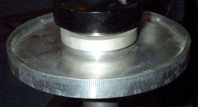
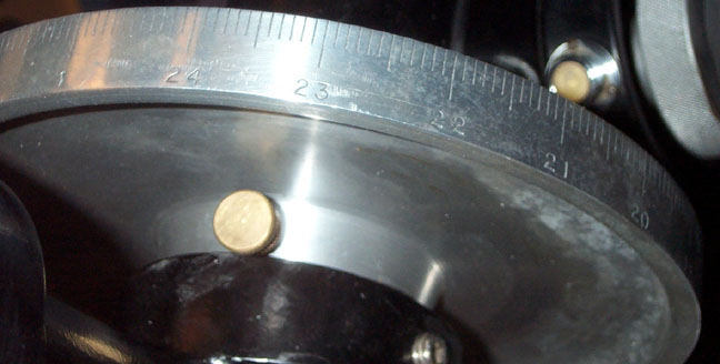
Declination - DEC |
|||||||||||
|
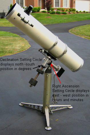
Declination Setting Circle on an Equatorial Telescope Mount |
|||||||||||
|
For every Latitude there is a corresponding Declination. If I am standing in Memphis at 35 degrees Latitude, every star that is at 35 degrees Declination will pass directly over my head at its Zenith where it crosses an imaginary North/South line called the Meridian dividing the eastern half of the sky from the western half. |
|
Longitude... ...defines the location of imaginary lines that run from north to south poles. There are 24 hours in a solar day (a 360 degree rotation of earth relative to the sun). One hour = 15 degrees - the typical width of a time zone. |
|||||||||||
 |
|||||||||||
|
Memphis is 90 degrees West Longitude half way between the Prime Meridian - 6 hours east which runs through Great Britain, and the International Dateline - 6 hours west near Japan. People in Memphis eat lunch about the same time Japan is waking up, and also about the same time as Great Britain is having dinner. |
|||||||||||
 |
|||||||||||
|
Right Ascension - R A ... |
|||||||||||
|
Right Ascension Setting Circle on an Equatorial Telescope Mount |
|||||||||||
|
...identifies north - south lines in space, whereas Longitude identifies north-south lines on earth. The earth rotates - relative to the stars - once every 23 hours and 56 minutes: a SIDERIAL or STAR DAY. Each day, earth also moves 1,584,00 miles along its 360 degree, 365 day orbit of the sun - a bit less than one degree per day. Earth rotates 360 degrees in one SIDERIAL DAY relative to the stars, but it will take four more minutes (One degree) to complete a Solar Day. 23 hours and 56 minutes + 4 minutes = one 24 hour day. SInce a Siderial Day is 4 minutes shorter than a Solar or calendar Day, the whole night sky shifts about 4 minutes toward the west each day. Therefore the night sky appears to make one revolution per year. While Longitude combined with Latitude determines points on earth, Right Ascension combined with Declination determines the positions of seemingly fixed objects in deep space. Solar System planets and satellites have Right Ascension coordinates which change constantly as they orbit the sun. Declination coordinates remain the same. |
|
Telescope mounts come in two basic flavors: Polar aligned telescope mounts have one axis parallel to that of Earth (which rotates west to east ) and another which pivots north south. These mounts are exclusively for astronomy and allow you to track an object by simply pivoting the telescope east to west at the same rate the earth rotates on the north south axis west to east. This is done manually, by a simple time clock motor, or computerized timing devices. Altitude (up and down) / Azimuth (left and right) mounts (ALTAZIMUTH or ALTAZ) have a vertical and a horizontal axis like a camera tripod. These mounts were at one time mostly for terrestrial use but have long been used for astronomy since the first telescope pointed skyward. The main disadvantage in astronomical usage is that one must pivot the telescope on both axes to track a target. Fortunately inexpensive computerized systems can make the telescope track and even locate objects regardless of mount type. |
|
|
|
|
|
|
|
||||||||||||||||||||||||||||||||||||||||||||||||||||||
|
So how do you begin finding your way? |
|
One needs a road map on earth in order to find specific geographical places. Likewise you need a map of the heavens -as seen from earth - to find objects in space. 1) Visit http://www.skyandtelescope.com and http://www.astronomy.com register on their web sites. This will allow you to access star chart which will identify objects in the sky - as seen from your area - at a specific time on the current date. Many other relevant resources are available. 2) Visit One Minute Astronomer . The trick to enjoying astronomy is arming yourself with relevant information. I have introduced individuals to astronomy only to discover that they know more than I do within a year! When I was younger, we just did not have the educational resources we have today. 3) Use you favorite search engine and enter astronomical search terms - like nebula, star cluster, creation, etc. Youll find that there are many paths into and around this hobby. Youll find places where the scientific information seduces you into thinking about exotic possibilities in the space time continuum. 4) Visit an astronomy club. There you will find people who and use know these processes and are able to explain and demonstrate them. It sometimes feels awkward being around more knowledgeable people, so be patient and participate. You will find people like myself who thrive on helping people get off to a good start. |
|
|
|